Where to find information:
Web:
https://flood-atlas.service.yukon.ca/
Phone: For urgent assistance: Call 9-1-1
Radio: CFYT 106.9 FM. During emergencies, a summary is broadcast on 105.5 FM in Dawson and the Klondike Valley.
Dawson-based Citizens can access some helpful information on flood preparation, emergency resources, and a guide to various advisories issued by Yukon Protective Services. Download our resource kit here.
TUESDAY, APRIL 30, 2024, 12:00 P.M.
*KLONDIKE RIVER BREAKUP UPDATE*
- The Flood Watch and High Streamflow Advisory for the Klondike River have ended. The Evacuation Alert for the Klondike River has been lifted.
- This means our TH Citizen Info Line is no longer active and we will no longer be posting daily updates to www.trondek.ca/breakup-updates. For further information on breakup activity on the Yukon, visit: Flood Atlas (yukon.ca)
Klondike River Breakup Update (Tues. April 30, 2024)
No advisories are in place for the Klondike River Valley. The Flood Warning and High Streamflow Advisory for the Klondike River have ENDED. The Evacuation Alert for the Klondike River Valley has been RESCINDED.
The Klondike River has broken. The ice jam at the Klondike Highway bridge has released and flushed through to the Yukon River, lowering water levels by 1.7 metres at the bridge. Two ice jams remain in place at Henderson Corner and the Bear Creek subdivision. Small rises in water levels will result from the release of the remaining upstream ice jams, but this does not represent a concern for flooding at this time. Once the river is open, water levels will start rising seasonally as freshet approaches.
No volunteers are needed to fill sandbags at this time.
This will be the last daily update related to Klondike breakup on local channels including 105.5 FM and 106.9 FM. Further information may be shared later today.
MONDAY, APRIL 29, 2024, 1:00 P.M.
*KLONDIKE RIVER BREAKUP UPDATE*
*
From Yukon Protective Services:
Advisories and alerts
Please note: If you’re in the evacuation alert zone within the Klondike Valley (including Prospector Road, Eureka Road, C4, and the Dredge Pond), stay vigilant and prepare to leave quickly if needed. Make sure your emergency kit is ready and your household emergency plan is in place.
A Flood Warning is now in place for the Klondike River from the Confluence up to and including Dredge Pond. A flood warning means that river levels have exceeded or will exceed banks or flood very soon. Areas beside affected rivers and lakes will flood.
A High Streamflow Advisory is in place for the Klondike River from Bear Creek up to the Dempster Bridge.
Where to get information and help:
Sandbagging volunteers are needed in Dawson today. If you’re interested, please join us at the Confluence at 1 pm (April 29). For more information, please email volunteer@cityofdawson.ca.
We’re continuously monitoring the flooding situation, but if you observe any changes along the river or near your property, please report it to the fire chief in your area:
Dawson Area: 867-993-2222
Rock Creek/Henderson: 867-993-2221
If you are in an area of flooding concern, there are sandbags available. You can find sand piles and empty sandbags at C4, the Mammoth statue, 5th Ave/Confluence, and the Klondike Valley Fire Hall.
Daily updates will be shared at www.yukon.ca/emergencies and by local governments. Tune into 105.5 FM, radio callsign VF5215, in the Klondike Valley and 106.9 FM in Dredge Pond and closer to town. Thank you for your patience while we work to strengthen the 105.5 FM signal in this area.
Forecast
Breakup is progressing on the Klondike River, with several ice jams in place between Henderson Corner and the Klondike Highway bridge. Ice jams that had formed in the Dredge Pond subdivision area have mobilized downstream, and are now jammed against the freeze-up jam at the Klondike Highway bridge, raising water levels and flooding low lying properties upstream.
The release of the ice jam currently in place between Henderson Corner and Rock Creek could mobilize downstream ice jams all the way down to the Klondike Highway bridge. If the ice at the Klondike Bridge remains resistant to the accumulation of upstream ice, further flooding is likely. If the ice from the bridge moves downstream without completely evacuating to the Yukon River, water levels could rise in the TH C-4 subdivision.
SUNDAY, APRIL 28, 2024, 3:30 P.M.
*KLONDIKE RIVER BREAKUP UPDATE*
🟠Drin Hǫzǫ Citizens,
• A Flood Watch is in place for the Klondike River from the Confluence up to and including Dredge Pond. This is the intermediate level of flood advisory, meaning river levels are rising and will approach or may exceed banks. Areas beside the river may flood.
• A High Streamflow Advisory is in place for the Klondike River from Bear Creek up to the Dempster Bridge.
• An Evacuation Alert is in place for the Klondike Valley. Be ready to leave on short notice. Now is a good time to review your household emergency plan and emergency kit.
Forecast
• Breakup is underway on the Klondike River, and increasing ice movements will be occurring over the next 24 to 48 hours. While the ice cover is decaying well, the formation and release of an ice jam near the Klondike Highway bridge is difficult to predict and has the potential to cause flooding. This is currently considered the highest risk area for flooding on the Klondike River.
• As flows increase, ice consolidations will continue to shift downstream resulting in localized water level rises; changes along the river are expected to be increasingly
dynamic through the weekend.
• Breakup on the Yukon River typically occurs after the Klondike and is currently predicted to occur slightly earlier than the 20-year rolling average of May 3.
Where to get information and help
• TH Citizens can call our info line at (867) 993-3125.
• Daily updates will be shared at www.yukon.ca/emergencies and by local governments. Tune into 105.5 FM in the Klondike Valley and 106.9 FM in Dredge Pond and closer to town. Thank you for your patience while we work to strengthen the 105.5 FM signal in this area.
• If you need sandbags to protect your property, you can find sand piles and empty and bags at C4, the Mammoth statue, 5th Ave./Confluence, and the Klondike Valley
• The next scheduled update will be provided at 2:00 p.m. tomorrow (Monday, April 28).
SATURDAY, APRIL 27, 2024, 2:30 P.M.
*KLONDIKE RIVER BREAKUP UPDATE*
🟠Drin Hǫzǫ Citizens,
• A Flood Watch is in place for the Klondike River from the Confluence up to and including Dredge Pond. This is the intermediate level of flood advisory, meaning river levels are rising and will approach or may exceed banks. Areas beside the river may flood.
• A High Streamflow Advisory is in place for the Klondike River from Bear Creek up to the Dempster Bridge.
• An Evacuation Alert is in place for the Klondike Valley. Be ready to leave on short notice. Now is a good time to review your household emergency plan and emergency kit.
Forecast
• Breakup is underway on the Klondike River, and increasing ice movements will be occurring over the next 24 to 48 hours. While the ice cover is decaying well, the formation and release of an ice jam near the Klondike Highway bridge is difficult to predict and has the potential to cause flooding. This is currently considered the highest risk area for flooding on the Klondike River.
• As flows increase, ice consolidations will continue to shift downstream resulting in localized water level rises; changes along the river are expected to be increasingly dynamic through the weekend.
• Breakup on the Yukon River typically occurs after the Klondike and is currently predicted to occur slightly earlier than the 20-year rolling average of May 3.
Where to get information and help
• TH Citizens can call our info line at (867) 993-3125.
• Daily updates will be shared at www.yukon.ca/emergencies and by local governments. Tune into 105.5 FM in the Klondike Valley and 106.9 FM in Dredge Pond and closer to town. Thank you for your patience while we work to strengthen the 105.5 FM signal in this area.
• If you need sandbags to protect your property, you can find sand piles and empty sandbags at C4, the Mammoth statue, 5th Ave/Confluence, and the Klondike Valley Fire Hall. Please feel free to take what you need.
• If you’re interested in volunteering to help, please email
volunteer@cityofdawson.ca.
• Another update will be provided at 2:00 p.m. tomorrow (Sunday, April 28).
FRIDAY, APRIL 26, 2024, 3:00 PM
*KLONDIKE RIVER BREAKUP UPDATE*
🟠Drin Hǫzǫ Citizens,
Forecast:
TH Citizens can call our Info Line at (867) 993-3125. Updates are also being broadcast on CFYT Radio at 106.9 FM close to town and on 105.5 FM in the Klondike Valley. We understand there have been some issues with the 105.5 FM signal. Mähsį̀cho for your patience as this issue is resolved.
If you need sand and sandbags, there are stations set up at the Tr’ondëk Subdivision (C4), on Front Street at 5th Avenue, in front of the Mammoth statue on Front Street, and at the Klondike Valley Fire Department. Please take what you need.
If you’re interested in volunteering to help, please email volunteer@cityofdawson.ca.
Mähsį̀ cho and k’änächa.
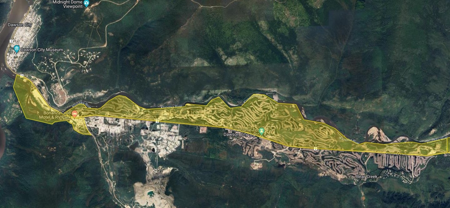
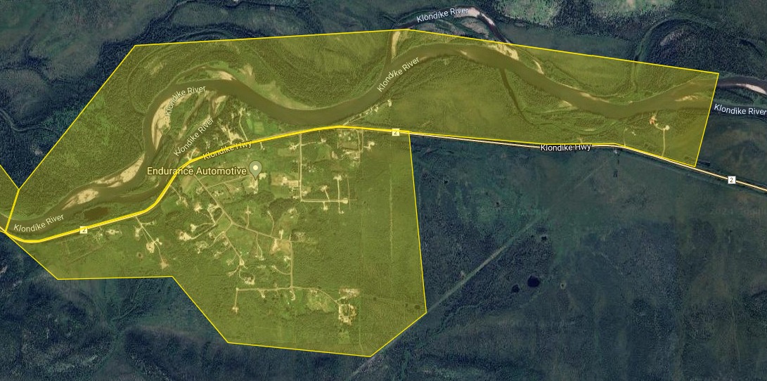
Klondike Valley – Hunker Creek Road to Rock Creek

Henderson Corner
THURSDAY, APRIL 25, 2024, 3:00 P.M.
*KLONDIKE RIVER BREAKUP UPDATE*
🟠Drin Hǫzǫ Citizens
• A Flood Watch is now in place for the Klondike River from the
Confluence up to and including Dredge Pond. This is the intermediate level of flood advisory, meaning river levels are rising and will approach or may exceed banks. Areas beside the river may flood.
• A High Streamflow Advisory is in place for the Klondike River from Bear Creek up to the Dempster Bridge.
• An Evacuation Alert is now in place for the Klondike Valley. Be ready to leave on short notice. Now is a good time to review your household emergency plan and emergency kit.
Forecast
• Snowmelt runoff will continue over the weekend and contribute to rising
water levels. Runoff will slow down during the cooling trend next week
and flows may decrease. The Klondike is expected to breakup within the
next 1 to 4 days. During that time water levels will fluctuate as jams
form and release. The formation and release of an ice jam near Klondike
Highway Bridge is difficult to predict but has the potential to cause
flooding. This is considered the highest risk area for flooding over the
next 5 days.
Where to get information and help:
TH Citizens can call (867) 993-3125 for information. This number is 24 hours a day/ 7 days a week during a Flood Watch event. If you are in immediate danger call 9-1-1.
• Daily updates will be shared at www.yukon.ca/emergencies and by
local governments. Tune into 105.5 FM and 106.9 FM for updates.
• If you need sandbags to protect your property, you can find sand piles
and empty sandbags at C4, the Mammoth statue on Front Street at 5th Avenue (Confluence), and the
Klondike Valley Fire Hall. Please feel free to take what you need.
WEDNESDAY, APRIL 24, 2024 2:30 P.M.
*KLONDIKE RIVER BREAKUP UPDATE*
![]() Drin Hǫzǫ Citizens
Drin Hǫzǫ Citizens
• A High Streamflow Advisory is still in place for the Klondike River. This is
the lowest level of flood advisory, meaning that river flows or levels are
rising or expected to rise rapidly, but no major flooding is expected.
Minor flooding in low-lying areas is possible. As breakup continues, the advisory level may be upgraded to a flood watch or warning depending on conditions.
• If you live near water, or in a flood-prone area, you should prepare to deal with flooding on your property. To learn about preparing for floods, visit www.PreparedYukon.ca.
• Current conditions and forecast: The ice cover on the Klondike River has
started to shift. Small ice consolidations have been observed between Rock Creek and the Klondike Highway bridge. A continued gradual degradation of the ice cover on the Klondike River is expected. Larger ice movements are likely to begin closer to the weekend, although cooler temperatures in the upstream basin should keep flows moderated. Breakup on the Klondike River is predicted to occur in the next 2 to 5 days.
• Daily updates on conditions will be shared here and on the Flood Atlasas breakup continues: www.yukon.ca/emergencies
• If you need sandbags to protect your property, sand piles and empty sandbags are located at C4, the Mammoth, 5th Ave/Confluence, and the Klondike Valley Fire Hall. Please feel free to take what you need
WEDNESDAY, APRIL 24, 2024 12:00PM *RESOURCE UPDATE*
![]() Drin Hǫzǫ Citizens. The weather is getting warmer and we’re keeping our eyes on the Yukon and Klondike rivers. Dawson-based Citizens can look for a package in their mail tomorrow with some helpful information on flood preparation, emergency resources, and a guide to various advisories issued by Yukon Protective Services.
Drin Hǫzǫ Citizens. The weather is getting warmer and we’re keeping our eyes on the Yukon and Klondike rivers. Dawson-based Citizens can look for a package in their mail tomorrow with some helpful information on flood preparation, emergency resources, and a guide to various advisories issued by Yukon Protective Services.
If you’d like to download the package online, you can find it here.
MONDAY APRIL 22 2024 *BREAKUP UPDATE*
![]() Drin Hǫzǫ Citizens. This is the first of our daily updates to keep you informed during break-up season.
Drin Hǫzǫ Citizens. This is the first of our daily updates to keep you informed during break-up season.
Please check this page or tune into 105.5FM for the latest news and information as it occurs.
• The Klondike River is now under a High Streamflow Advisory. This is the lowest level of flood advisory, meaning that river flows or levels are rising or expected to rise rapidly, but no major flooding is expected. Minor flooding in low-lying areas is possible. As breakup continues, the advisory level may be upgraded to a flood watch or warning depending on conditions.
• This advisory means that if you live near water, or in a flood-prone area, you should prepare to deal with flooding on your property.
To learn about preparing for floods, visit www.PreparedYukon.ca.
Water level forecast: Snowmelt runoff will continue increasing and water levels will rise more rapidly this week. Larger ice movements are likely to begin mid-week with breakup likely occurring in the next 4 to 9 days. The weather cooling trend predicted on the weekend increases the uncertainty with this forecast.
Where to get more information:
Read the full advisory on the Flood Atlas, where Yukon government hydrologists will also be sharing daily conditions updates: https://flood-atlas.service.yukon.ca/.